
FEMA Elevation Certificates
The Federal Emergency Management Agency (FEMA) Flood Insurance program requires that an Elevation Certificate be completed by a Licensed Land Surveyor. A FEMA Elevation Certificate and a flood insurance policy are often required by mortgage lending institutions prior to closing a purchase transaction.
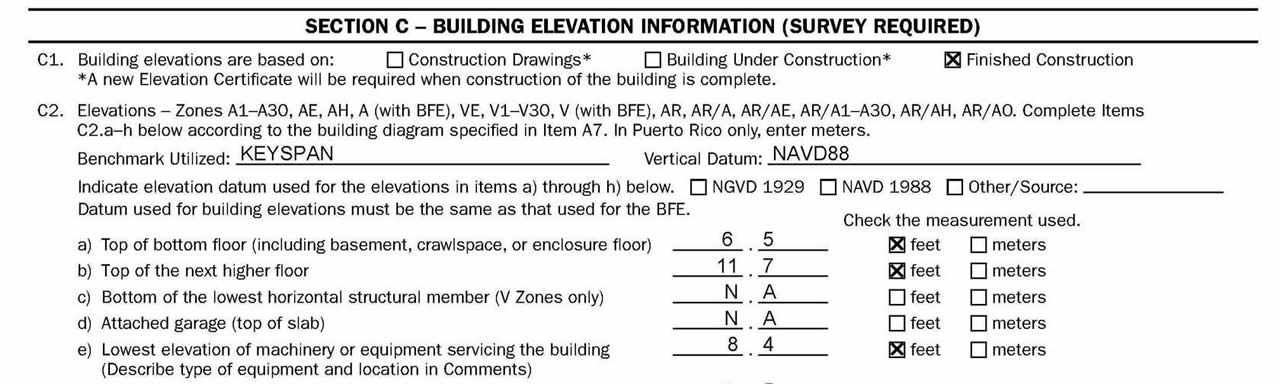
In Suffolk County, FEMA completed the remapping and update of the Flood Insurance Rate Maps (FIRM) in 2009. The official adoption date of the new flood mapping was September 25, 2009. The vertical datum (sea level reference) was changed to the North American Vertical Datum 1988 (NAVD88) from the old National Geodetic Vertical Datum 1929 (NGVD29).
We will conduct field measurements by either standard ground methods or GPS observations to reference the NAVD88 datum. We will measure the elevation of the dwelling's mechanical systems, floor elevations and adjacent grades and also measure the basement/crawl space areas including any existing flood vents for reporting on the certificate. The survey crew will require access to the interior of the dwelling and any areas containing mechanical service systems.